Wairoa to Lake Tutira #

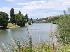
Gradients are gentle for the first 25 km, but then there's a steepish climb over Taumatataua Hill (250 m). The descent into the Mohaka river valley offers good views both to the sea and inland up the valley. After crossing the river, the road climbs up the side of the valley, passing under the impressive railway bridge which towers 100 m over the river below. After this climb to 200 m is over, the road undulates a bit and then descends gradually to Putorino, which consists of a few farms and a popular café. After the steepish 100 m climb out of Putorino the road rolls easily all the way to Lake Tutira. You can stock up with provisions at a small shop/café at Tutira village, just before you get to the lake.
There's a idyllically-situated DOC camp site at the southern end of Lake Tutira. Turn off the highway and continue for 1 km past the rest area with shelter near the main road, to the camping area. Facilities are very basic (toilets and water taps) but the site is far enough away from the main road to be quiet and restful, and there are various wild-life to look at. Unfortunately, the lake is not always suitable for swimming, see signs at the lakeside. A walking track (unsigned) leads up the hill above the camp site to a small shelter, from which there are superb views out over the lake.
