Omakau to Lindis Crossing
The Thompson Track is a little known but worthwhile old gold road from Omakau (on the rail trail) to Wānaka. It is also known as the 'Rise and Shine Road' or 'Back of Beyond' by locals in an obscure reference to its historic past. There are several old gold town relics on this route. There are the historic remains of the town of Bendigo, various abandoned mine shafts, the remains of sod brick cottages and an impressive 'battery' or 'stamper'. These were generally cast iron banks of water or steam driven hammers used to crush gold-bearing quartz.
So, where to start from? My favourite campsite in this area is at Ophir (2 km from Omakau) a campsite attached to the Backpackers currently owned by Bill and Lois Galler, although rumours are that it is to be sold. Ophir is one of my favourite old gold towns and a quiet spot redolent of other eras and other lives.
Let me add a small piece of local drama regarding Ophir. There was once a murder in the Ophir hotel (otherwise known as Blacks Hotel) and a woman was shot dead just by the hearth in the public bar. A bullet hole in the hearth is still visible. The murder was apparently, the result of a tragic love triangle. It is unwise to inquire too loudly of the event however as it occurred relatively recently rather than being part of Ophir's more distant and colourful past. Those associated with the event are liable to be leaning on the bar or possibly serving behind it.
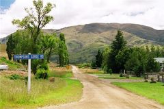
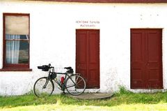
On the way you might like to take in Matakanui, or Tinkers, a 3 km diversion. This is an established old gold town with a few, still lived-in, substantial sod brick buildings including the old Tinker's hotel which is now, sadly, a privately owned residence and very dry. Further on, the first sign of the Thompson Track appears as a hand painted notice warning of the number of gates to be opened and closed.
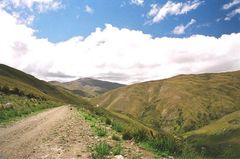
The track is well formed and about 37 km long initially winding up through hills and over streams and small valleys. The first section affords great views back toward the flat plain and the Raggedy Range in the distance.
While the surface is good you may be pushing a good part of the way as the road climbs steeply at first and then becomes a little easier as the incline lessens. The Stamper Battery is located near the top of the range. On the day I visited the site, there were a number of geckos sunning themselves on the rocks. They scattered as I approached. These are small and harmless lizards but they give you a start when you are not ready for them.
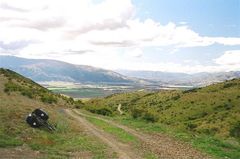
The view from the top over the valley towards Lake Dunstan is impressive, as is the view toward the great Pisa Range in the far distance toward Wānaka. The descent is gradual enough. If you want to visit the ruined gold town of Bendigo, take the left hand side track directly at the bottom of the hill (there will be a restored miner's hut a hundred metres or so to your right in a walled paddock). This detour will add some ten or so kilometres to your journey overall but is worth it if you have an interest in historic ruins.
You can turn right as you come off the track onto Highway 8 and stop at Tarras (15 km from turn-off) where there is a store and camping at the local school. There is a hostel a few kilometres out of the township. Or you can head left on Highway 8 to Cromwell (25 km from turn-off approx, all facilities). Or you can push on to Wānaka a further (50 km approx all facilities). If you take a day's supplies, you can camp discreetly on the track itself.